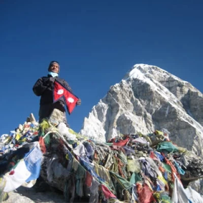
Sagarmatha National Park
Sagarmatha (Mt. Everest) National Park was established in 1976, covering an area of 1,148 sq. km in 1976, in the Himalayan ecological zone in the Khumbu region of Nepal. The park includes the upper catchment areas of the Dudhkoshi and Bhotehoshi Rivers and is largely composed of rugged terrain and gorges of the high Himalayas, ranging from 2,845 m at Monjo to the top of the world's highest mountain—Sagarmatha—at 8,848 m above sea level. Other peaks above 6,000 m are Lhotse, Cho Oyu, and Thamserku. Nuptse, Amadablam, and Pumori. The famed Sherpa people, whose lives are interwoven with the teachings of Buddhism, live in the region. The renowned Tengboche and other monasteries are common gathering places to celebrate religious festivals such as Dumje and Mane Rumdu. In addition to Tengboche, Thame, Khumjung, and Pangboche are some other famous monasteries. For its superlative natural characteristics, UNESCO listed the SNP as a World Heritage Site in 1979.
Flora and Fauna at Sagarmatha National Park
The vegetation found at the lower altitude of the park includes pine and hemlock forests, while fir, juniper, birch, rhododendron, scrub, and alpine plant communities are common at the higher altitude.
The Sagarmatha National Park is home to the red panda, snow leopard, musk deer, Himalayan tahr, marten, Himalayan mouse hare (pika), and over 118 species of bird including the Impeyan pheasant, snow cock, blood pheasant, red-billed cough, etc.
How to Get There?
The most common ways to reach the park from Kathmandu are:
- Flight to Lukia and two days walk
- Bus to Jiri and 10 days walk
- Flight to Tumlingtar and 10 days walk
- Flight to Phaplu and 5 days walk
Buffer Zone of Sagarmatha National Park
The government of Nepal declared a buffer zone in and around the park in 2002 with the objective of reducing biotic pressure in the slow-growing vegetation. The government has also made a provision of plowing back 30 - 50 percent of the revenue earned by the park to community development activities in the buffers zone. In collaboration with local people, it aims to conserve biodiversity in the region.
Popular Trekking Routes in Sagarmatha National Park
The trek from Namche to Kala Pathar and Everest Base Camp is very popular. The Gokyo Lake and Chukung Valleys also provide spectacular views. The Thame Valley is popular for Sherpa culture while Phortse is famous for wildlife viewing. There are some high passes worth crossing over. However, the trekkers must have a guide and proper equipment for the trek.
Here is a List of the Most Popular Treks in the Everest Region
- Everest Base Camp Trek—9 Days
- Everest Base Camp Trek and Fly Back Helicopter—9 Days
- Everest 3 Passes Trek—18 Days
- Luxury Everest Base Camp Trek—8 Days
- Gokyo Chola Pass Trek—16 Days
- Everest Base Camp Trek By Road (Escape the Flight)
Safety Precautions
High altitude sickness can occur if elevation is gained too rapidly and without proper acclimatization. The symptoms are - headache, difficulty in sleeping, breathlessness, loss of appetite, and general fatigue. If someone develops the symptoms, stop ascending immediately; if symptoms persist, the only proven cure is to descend to lower elevations.
Medical advice could be sought from Kunde Hospital or Pheriche Health Post. Radio communication with Kathmandu is available at Park Headquarters.
Langtang National Park
Langtang National Park was established in 1976 to conserve the unique flora and fauna of the region. It is the nearest national park of the capital Kathmandu in the Central Himalayan Region. The 1710 sq. km. of the park extends over parts of Nuwakot, Rasuwa, and Sindhupalchok districts in the southern mountainous terrain of the Nepal-China (Tibet) border. In 1998 an area of 420 km2 in and around the park declare as a buffer zone. The park represents a meeting point between Indo-Malayan and Palearctic realms and holds a rich biodiversity.
Local communities work together with the park office to manage buffer zones. Local communities have a decision-making role in the management of such areas. Additionally, the local communities or the BZ receive 30 to 50 % of the Langtang National Park revenue for the better management of natural resources to ensure a sustainable supply of resources and community development.
Climate:
September through May offers a variety of natural splendors, from lush temperate river valleys with screeching langur to spectacular old-growth forests and glacial-craved cliffs rimmed by snow-covered peaks. The weather is also relatively dry except January-February when one may come across snow. Autumn is the best time to visit the Park. By April, bursts of red, pink, and white rhododendron stretch into towering canopies of fir and oak forests. The advent of warm weather makes the Yak and Chauri herds ascend to higher elevations, making occasional camps in the pasturelands, to follow years of tradition. From June to August, skies are heavy with monsoon rains. During August, a lively festival at Gosaikunda Lake attracts thousands of Hindu pilgrims, and September witnesses a spectacular display of wildflowers, while livestock herds, once again, return to lower pastures
Flora and Fauna:
Sub-tropical vegetation characterized by Sal (Shorea robusta) forest in the southern section of the park is gradually taken over by hill forest (2000-2600m) consisting of Chirpine, Rhododendron, and Nepalese alder. The temperate zone (2600-3000m) is covered mainly by oak forest fading to old growth forest of silver fir, hemlock, and larch in the lower sub-alpine zone (3000-3600m). The Nepalese larch (larixnepalensis), the only deciduous conifer in the region, is found in this park and a few places elsewhere. Throughout these zones, different species of Rhododendron such as R. arboretum, R. barbatum, R. campanulatum, and R. lepidotum (scrubs) to name a few, form a colorful understory. Tree species such as birch, silver fir, Sorbus micropyle, and twisted
Rhododendroncampanulatum is found near the tree line. It is here at 4000m Juniper and Rhododendron shrubs (R. anthopogon) slowly dissolve into expansive alpine grassland meadows.
Langtang's expansive high meadows provide summer habitat for numerous ungulate species such as musk deer and Himalayan tahr. The park is also well known for its populations of red panda, Himalayan black bear, snow leopard, wild dog, goral, serow, and more than 250 species of birds.
How to get there?
Three main trek routes: 1) Langtang Valley 2) Helambu and 3) Gosaikunda Lake cover much of the Langtang National Park and the southern Helambu region. Langtang and Helambu regions are connected through Lauribina La. All routes have the facilities of locally operated hotels/lodges, teahouses, and campgrounds for groups. The park offers a choice of moderate to more difficult hiking with a duration ranging from 3 days to 3 weeks. Lodges are open year-round, except peak winter, when they block the trails.
Trekkers who take extra time to explore trailside wilderness (e.g. near Ghora Tabela and Kyanjin) hilltop viewpoints (Kyanjin), and cultural sites (notably in Langtang village and Melamchighyang, Tarkeghayang, and Shemathang) will be well rewarded. One has to be self-sustaining to venture into remote areas of the Park such as Panch Pokhari (five lakes), east of Helambu, the toe of Langshisa glacier, and the upper-level valley from Kyanjin: and over the challenging Ganja La pass in the upper Langtang Valley.
Here is a List 5 Best Trek in Langtang National Park
- Langtang Valley Trek -11 Days
- Gosaikunda Trek -09 Days
- Langtang Helambu Trek -17 Days
- Tamang Heritage Trail Trek -07 Days
- Helambu Trek -09 Days
Acclimatization and Safety:
High altitude Sickness (HAS) can be life-threatening if elevation is gained too rapidly without proper acclimatization. Medical doctors advise against ascending more than 400m a day once above 3000m elevations. Alternatively, one can spend an extra night at 3000m and 3500m before ascending higher.
Over-exertion and dehydration contribute to HAS. Drink at least 3-4 liters of water every day besides tea and coffee which act as diuretics. Watch the health of your companions and porters. Symptoms of HAS are headache, dizziness, trouble in breathing and sleeping, loss of appetite, nausea, and general fatigue. If someone exhibits symptoms of HAS, please ensure they are promptly taken to a lower elevation.
The Langtang-Helambu trails are rocky and slippery after rain or frost. Watch out for falling rocks while crossing landslides but do not stop. Never hike alone. Hiring local guides is strongly recommended on Ganja La (5120m) trek and on Lauribina La (4600m) during winter. Carrying a comprehensive first-aid kit is advisable as there are no medical facilities out of Dhunche. Telephone facilities are available at Singh Gompa and at major settlements in Helambu.
If you need any further information, please don t hesitate to contact us at Nepal Mother Houseanytime.
Shivapuri Nagarjun National Park
Shivapuri Nagarjun National Park (159 sq km) is situated on the northern fringe of Kathmandu Valley and lies about 12 km away from the center of the capital city. The area was gazetted as the country's ninth national park in 2002. Before its declaration as a national park, it was managed under the Shivapuri Watershed Development Board and later declared Shivapuri Watershed and Wildlife Reserve.
Flora and Fauna at Shivapuri National Park
Shivapuri lies in a transition zone between subtropical and temperate climates. The vegetation consists of various natural forest types including pine, oak, rhododendron, etc, depending on altitude and aspect. Recorded wildlife in the park includes mammalian species such as Himalayan Black bears, leopards, jungle cats, and rhesus monkeys. The Shivapuri Nagarjun National Park is also home to 177 species of birds, including at least 9 threatened species, 102 species of butterflies with several rare and endangered species, and 129 species of mushrooms.
Water Resources at Shivapuri National Park
Shivapuri is one of the main sources of drinking water for Kathmandu Valley. Every day about 30 million liters of water is tapped from rivers such as the Bagmati and the Bishnumati and several other smaller streams.
Places of Interest of Shivapuri National Park
The Shivapuri Nagarjun National Park is easily accessible from Kathmandu. Visitors are attracted to the park for trekking. Trekking routes to Nagarkot, Gosaikunda, Helambu, and Langtang National Park also pass through the park. Several religious sites for the Hindus and the Buddhists lie inside the park. On Nepalese New Year's Day, which falls in mid-April, pilgrims from Kathmandu Valley and neighboring areas flock to Baghdwar and Bishnudwar of the park from where the sacred rivers Bagmati and Bishnumatii originate. Visitors can have breathtaking views of the high Himalayas from the northern aspects of the park. Likewise, the panoramic views of Kathmandu Valley could be seen from the southern slopes of the park.
Famous Trekking Destinations within the Park
- Panimuhan, Park HQ - Shivapuri peak (12 km)
- Nagigumba - Baghdwar - Chisapani (18 km)
- Nagigumba - Shivapuri peak (6 km)
- Kakani - Shivapuri
- Jhuje - Chisapani (12 km)
- Sundarijal - Chisapani (22km)
Here is a List of the most popular treks in the Shivapuri National Park
- Chisapani Nagarkot Trek - 04 Days
- Shivapuri National Park Hike—03 Days
- Kathmandu Hiking- 01 Day
- Kathmandu Valley Trek - 04 Days
- Kathmandu Valley Ridge Trek - 08 Days
If you require any further information, kindly feel free to contact the Nepal Mother House Team at any time.
Bardia National Park
Bardia National Park is the largest national park in the lowland Terai, covering an area of 968 sq. km. The park in Nepal's Western Terai was established to protect representative ecosystems and conserve the tiger and its prey species. Initially, a small area was gazetted as the Karnali Wildlife Reserve in 1976.
1500 households of the Babai Valley were resettled outside the park allowing the vegetation and wildlife to flourish. In 1982, it was renamed Bardia Wildlife Reserve, and in 1984 it was extended to its current size. The reserve was given the status of a National Park in 1988. Greater One-horned Rhinoceros were translocated from Chitwan National Park in 1986, 1991, 1999, 2000, 2001 and 2002.
In 1997, an area of 327 km2 surrounding the park was declared as a buffer zone, which consists of forests and private lands. The park and local communities jointly manage the buffer zone. Together they initiate community development activities and manage natural resources in the buffer zones. An elephant ride provides a different view of the park as one can go off the main trail, Morning and late afternoon is the ideal time to go on a ride. Karnali River is a suitable home for Gangetic dolphins. Babi Valley is a majestic place to visit where flagship Rhinos, tigers, and elephants can be observed in the wilderness site.
Babai Valley in Bardia National Park
The Babai Valley extending from Parewa Odar to Chepang (bridge) was included In the park in 1984. The pristine valley is characterized by rich biodiversity. The major vegetation and forest types are wooded grassland and riverine forest. The translocated rhinoceros from Chitwan were reintroduced in this valley. The luxurious forests in the east of the park also provide a favorable habitat and corridor for several wildlife species. The Karnali River is home to the endangered Gharial crocodile and Marsh mugger. The blue waters also provide a habitat for the endangered Gangetic dolphin. Large Mahasheer, a game fish, is considered an excellent catch.
The fast-flowing water also provides excellent rafting expeditions that can stop in the park. Riverine forests along with the shores of the river create prime habitat for birds such as Herons, egrets, black-necked storks, and Little pratincole. The Tharu ethnic group is native to this area. Traditionally they are subsistence farmers and practice their own tribal religion. Handicrafts made by the community members could be bought as souvenirs.
The climate of Bardia National Park
The park has three distinct seasons, each providing a unique experience. From October through early April, the weather is dry. The days are warm, and the nights are cool and pleasant. From April to June the temperatures warm up, peaking up to 450c in May. The hot sticky days give way to the monsoon rains that last until September.
Flora and Fauna of Bardia National Park
The Bardia National Park offers various experiences in its vast undisturbed wilderness. About 70% of the forest consists of Sal trees with a mixture of grassland and riverine forests. Sal leaves are used in festivals and religious offerings. The park is home to endangered animals such as the Royal Bengal tiger, wild elephant, Greater one-horned rhinoceros, swamp deer, and black buck, The other endangered species include the gharial crocodile, marsh mugger, and Gangetic dolphin. Endangered birds found in the park are Bengal florican, lesser florican, and Sarus crane, More than 30 different mammals, over 230 species of birds and several species of snakes, lizards, and fish have been recorded In the park's forest, grassland, and river. In addition to the resident species, several migratory birds visit the park.
Facilities available in Bardia National Park
Museum and Tharu's culture are available for visitors at HQ. The wireless radio communication facility at the park headquarters could be used in an emergency, If you are traveling by private vehicle make sure that you have an ample amount of fuel. Be advised to carry a comprehensive first-aid kit including medicines for intestinal problems. There is a community health post at Thakurdwara. You can spend your nights at the lodges surrounding the pork. These lodges provide service to tourists.
How to get there?
You can take a bus from Kathmandu to Nepalgunj or take the daily flight. From Nepalgunj, a bus service is available to the park HQ at Thakurdwara during the dry season.
Rara National Park
Rara National Park is located in the North-Westem high mountains of Nepal. The park was gazetted in 1976 to conserve the unique beauty of Lake Rara, and to protect the representative flora and fauna of the Humla-Jumla region. The park is Nepal's smallest protected area, comprising an area of 106 sq. km. There were two villages Rara and Chhapru within the park. The residents of the two villages were resettled in Banke district, outside the park.
Rara Lake (Mahendra Tal), situated at an elevation of 2990 m. is the main feature of the park. The lake is oval-shaped with an east-west axis and has a maximum length of 5 km and a width of 3 km. Surrounded by magnificent conifer forests, it is Nepal's biggest lake (10.8 sq . km) with a depth of 167 m. Its radiant blue waters are home to the snow trout (Schizothorax oremus Sinuatus), the only fish recorded in the lake.
During winter, bird lovers can enjoy many migratory birds. In summer, Himalayan flowers surround the lake creating a colorful landscape. The elevation of the park ranges from 2800 m to 4039 m. Chuchemara Peak (4039 m) is the highest point in the park. Located on the southern side of the lake, it provides an excellent backdrop to Lake Rara. The snowcapped summits of Ruma Kand (3731m) and Malika Kand (3444m) located on the northern side of the lake, provide beautiful views of the lake to the south, and the beautiful Mugu-Kamali River valley to the north. MurmaPeak also provides an excellent view of the parking area.
The lake drains to the Mugu-Kamali River via Nijar Khola. The majority of the vegetation in the park is dominated by blue pine. Interspersed amongst the pines, are found several species of rhododendrons. Blue pine, herbs, marshlands, and tussock grasslands inhabit the area surrounding the lake. In the Nisa Khola Valley, pine and spruce give way to mixed woodland containing walnuts and Himalayan poplar. Rhododendron, fir, oak, and birch species can be found in the sub-alpine region.
The climate at Rara National Park
Summer is pleasant. However, winter is freezing. The best time of year to visit the park is September/October and April to May. December through March, the temperatures drop to below freezing, and heavy snowfalls occur up to one meter, closing high passes.
April to June is warm but the season gives way to monsoon season, June to August.
Flora and Fauna at Rara National Park
The Rara National Park is characterized by, sub-alpine and high temperate vegetation. Common plant species include fir, pine, and birch, rhododendron, hemlock, oak, juniper, and spruce. The park is home to around 20 different species of mammals. They include Musk deer, Himalayan black bears, leopards, Jackal, Himalayan tahr, yellow-throated martens, otters, and wild dogs. Common langur. Rhesus macaque and Red panda. The park has recorded 214 species of birds. Some of the important species include coots, snowcocks, and different species of pheasants, grebes, mallards, common teal, red-crested pochard, and gulls. During winter, many migratory birds join the residential Gallinaceous birds.
Facilities available at Rara National Park
It is advisable to bring a comprehensive first-aid kit since there is no health post in the area. Arrangements should be made through a trekking agency. There are basic accommodations in the Rara National Park. Trekkers can be staying at a tea house this day during Rara Lake Trek.
How to get there?
Rara National Park is 2.5 days trek via Jumala or 10 days trek from Surkhet.
Shey Phoksundo National Park
Shey-Phoksundo National Park is in the Trans-Himalayan region of northwest Nepal. It is Nepal’s largest National Park covering an area of 3,555 km2. It was established in 1984 to preserve a unique Trans-Himalayan ecosystem with a diversity of flora and fauna. The Park’s climatic differences, altitude variations, and different zoogeographical regions support a diverse range of biotic systems. In 1998, an area of 1349 km2 surrounding the Shey-Phoksundo National Park was declared as a buffer zone, which consists of forests and private lands. The park and local communities jointly manage the buffer zone. Together they initiate community development activities and manage natural and cultural resources.
Shey Phoksundo National Park provides a diversity of spectacular landscapes. Elevations in the park range from 2,130m in Ankhe to 6,883m at the summit of Kanjiroba Himal. Much of the park lies north of the Himalayan crest. Nepal’s deepest and second-largest lake, Phoksundo Lake, lies in the upper regions of Suligad. Near the lake’s outlet is the country’s highest waterfall. The major rivers in the Shey-Phoksundo National Park are the Khung, Nmajung, and Panjang, The Suligad and Jugdual Rivers, which are the major tributaries of the Thuli Bheri River; and the Langu River, which drains the high Dolpo plateau to the east and flows westward. Phoksundo Lake is famous for its magnificent turquoise color and the spectacular scenery clearly ranks it among the most scenic mountain parks in the world. Ringmo village, a typical Tibetan village, is scenically nestled in the area. Near and above the lake area, one can find numerous beautiful glaciers. The park contains many gompas (monasteries) and religious areas. The most famous, Shey Gompa was established in the 11th century. The Thashung Gompa located near Phoksundo Lake was built about 900 years ago to conserve wildlife.
Climate
Due to its location spanning both the northern and southern aspects of the Himalayan crest, the park experiences a wide range of climatic conditions. Most of the precipitation in the area occurs during the monsoon (July-September), although the Dhaulagiri and Kanjiroba Ranges form a massive barrier preventing most of the rain from reaching the Trans-Himalayan area. The park contains the transition from a monsoon-dominated climate with 1500 mm. of annual precipitation in the south (Suligad) to an arid climate with less than 500 mm. a year in the northern slopes. Winters are quite severe, with frequent snowfalls above 2,500m. and the temperature’s remaining below freezing above 3,000m. through much of the winter.
Flora and Fauna
The flora found within the park is extremely diverse. The northern regions contain barren areas of the upper Himalayas and the Trans-Himalayan slope lands consisting of some rhododendron, caragana shrubs, and Salix, Juniper, white Himalayan birch, and the occasional silver fir dominate the high meadows of the Himalayas. Less than five percent of the park is forested, with much of it lying in the southern portion. The Suligad Vally’s flora consists of blue pine, spruce, hemlock, cedar, silver fir, poplar, rhododendron, and bamboo. The park also contains 286 species of ethnobotanical importance.
The park provides important habitats for endangered species including the snow leopard, grey wolf, musk deer, blue sheep, goral, great Tibetan sheep, Himalayan tahr, leopard, jackal, and Himalayan black bear are also found in the park. The park is home to six reptiles and 29 species of butterflies, including the highest-flying butterfly in the world, Paralasa Nepalaica. The park provides habitat for over 200 species of birds, among which include yellow-throated marten, Tibetan partridge, wood snip, white-throated tit, wood accentor, and crimson-eared rosefinch.
Facilities
Local accommodations are available in Dunai, Sangta, Chhepka, and Ringmo. Campsites with rubbish pits, toilets, and shelters are available throughout the park. Trekking lodges are located in Dunai, Chhepka, and Ringmo and provide food and limited supplies. Park offices are located at Suligad, Chhepka, Palam Ringmo, and Toijem, At the headquarters in Palam there is a small visitor center.
How to get there?
The easiest way to reach the park is by air from Nepalgunj to the Juphal airstrip in Dolpa followed by a half-day walk to the park entrance at Suligad.
Culture
The park is home to more than 9,000 people and their villages are among the highest settlements on Earth. Most of the inhabitants of the park practice Bon Buddhism, an ancient religion with roots in Animism and Buddhism. The Bon-po religion, which forms the entire cultural base for Tibetan Buddhism, was founded 18,000 years ago, during the Zhang Zung Empire of today's western Tibet. The landscape is dotted with sacred monasteries, thangka paintings, and shortens. The local community is heavily dependent on trade with Tibet and agriculture. This area is also famous for its salt trade caravans.
Trekking
Individual trekking is permitted to trek to Ringmo or Phoksundo Lake. The Tran-Himalayan region of inner Dolpa is restricted to group trekking only; a group trekking permit is needed and can be arranged through any recognized trekking agency in Nepal. Likewise, Phoksundo Lake Trek, Lower Dolpo Trek, and Upper Dolpo Trek can do in the region.
Khaptad National Park
Khaptad National Park is located in the far-western region of Nepal. The park was gazetted in 1984, covering an area of 225 sq. km. The area of the buffer zone is 216 sq. km. The park is the only mid-mountain national park in western Nepal, representing a unique and important ecosystem. The late Khaptad Swami moved to the area in the 1940s to meditate and worship. He spent about 50 years as a hermit and became a renowned spiritual saint.
The park offers a challenging yet rewarding experience, unlike any other protected area in Nepal. The Khaptad Baba Ashram is located near the park headquarters. The Tribeni confluence made by three rivers, and a Shiva temple are on the way to Park Headquarters. Ganga Dashahara is celebrated here during Jestha Purnima and many pilgrims visit the park during the festival. Sahashra Linga is another religious site situated at 3,200 m above sea level which is the highest point in the park. Other religious places include the Ganesh temple, Nagdhunga, and Kedardhunga. These areas are considered as places for meditation and tranquillity and should not be disturbed. Tobacco products, alcohol, and sacrificing of animals are prohibited in these areas.
There is a small museum and a view tower at the park headquarters. To the north one can see the Saipal Himalayan Ranges- In the other direction the vast green mid-hills of Nepal can be seen clearly. There are 22 open patches of Patans (pastureland) mixed together with the forests inside the park. The local people graze their livestock in the Patans during the summer season. In the northeastern part of the park, there is a lake called Khaptad Daha. During the full moon of August - September a festival is called Purnima celebrated here.
Climate at Khaptad National Park
The seasons of spring (March-May) and autumn (October-November) are the best times to visit the park. The temperature ranges from 10°c to 20°c offering pleasant trekking weather. The monsoon begins in June and last until September during this time paths become muddy and slippery. From December to February winter brings snow and chilling winds.
Flora and Fauna at Khaptad National Park
The flora of the Khaptad National Park can be divided into three basic vegetation zone's-subtropical, and temperate. In the lower altitudes (1000 - 2000 m), subtropical vegetation dominates the landscape; Forest mainly consists of Montane Sal, Pines, and Alder species. From 1800 - 3000 m temperate type dominates the landscape.
The forest there is comprised of lower temperate mixed broad-leaved species (Lindera nausea, Cmnamomum Tampa. etc), temperate mixed evergreen species (Spruce, fir, hemlock, oak. etc), and upper temperate broad-leaved species (Aesculus indica, maple, etc.) Oak, birch, and rhododendron are the major species found there. Intertwined into the landscape of the Khaptad plateau are the Patans (pastureland) with beautiful flowers (about 135 species) that bloom in the summer and late spring. The grassland flowers consist of primulas, buttercups, and wild berries. A wide variety of medicinal herbs (about 224 species) occur inside the park.
The park is reported to have 266 bird species with migratory birds joining the residential ones. It supports about 175 breeding bird species. Some of the common ones are the Impeyan, pheasant (Dhanphe), Nepal's national bird, and many types of partridges, flycatchers, bulbuls, cuckoos, and eagles. A wide variety of butterflies, moths, and insects are also forming a part of the Khaptad ecosystem. The park provides habitat for some 20 different, species of mammals. Common ones include barking deer, wild boar, goral, Himalayan black bear, Yellow-throated Marten, and Rhesus and Langur monkey. Other includes leopard, wild dogs, jackal, and musk deer.
Facilities at Khaptad National Park
Currently, there are no lodges or hotels in the park. Trekkers must be self-sufficient in tents, food, fuel, and all other supplies. Make sure to bring a first-aid kit because there are no medical facilities available within the park.
How to get there?
The best way to reach the parking area is to fly from Nepalgunj to Dipayal and the local buses are available for Silgadhi, Doti. From Silgadhi Bazaar one has to hike 6 hours to the park entrance and another 7-8 hours to the Park Headquarters. Other options are-flight to Dipayal followed by a three-day walk, a flight to Achham or Bajhang followed by a two-day walk, or a flight to Bajura followed by a four-day walk. However, Dipayal and Accham airports are rarely open.
Chitwan National Park
The park is situated in south central Nepal, covering 932 km2in the subtropical lowlands of the inner Terai. The area comprising the Tikauli forest-from Rapti river to the foothills of the Mahabharat-extending over an area of 175 km2 was declared Mahendra Mriga Kunj (Mahendra Deer Park) by the late King Mahendra in 1959. In 1963, the area south of Rapti River was demarcated as a rhinoceros sanctuary. The area was gazetted as the country's first national park in 1973, recognizing its unique ecosystems of international significance. UNESCO declared RCNP a World Heritage Site in 1984, In 1996 an area of 750 km2 surrounding the park was declared a buffer zone, which consists of forests and private lands including cultivated lands.
The Chitwan National Park and the local people jointly initiate community development activities and manage natural resources in the buffer zone. The government of Nepal has made provision to provide 30-50 percent of the park revenue for community development and natural resource management in the buffer zone.
Features of Chitwan National Park
The park consists of a diversity of ecosystems-including the Churia hills, Ox-bow lakes, and the flood plains of the Rapti, Reu, and Narayani Rivers. The Churia hills rise slowly towards the east from 150 m. to more than 800 m. The western portion of the park is comprised of the lower but more rugged Someshwor Hill. The park shares its eastern boundary with the Parsa Wildlife Reserve.
The climate of Chitwan National Park
The park has a range of climatic seasons each offering a unique experience. October through February with average temperatures of 25oc offer an enjoyable climate. From March to June temperatures can reach as high as 43oC, The hot humid days give way to the monsoon season that typically lasts from late June until September, Rivers become flooded and roads are impossible.
In late January, local villagers are allowed to cut thatch grasses to meet their needs, which offers a better viewing of wildlife to visitors. In September, November, February, and April, migratory birds join the residential birds and create spectacular bird-watching opportunities. While the monsoon rains bring lush vegetation, most trees flower in late winter. The Palash tree, known as the "flame of the forest' and the silk cotton tree have spectacular crimson flowers that can be seen from a distance.
Flora and Fauna at Chitwan National Park
The Chitwan National Park consists of tropical and subtropical forests. Sal forests cover 70 percent of the park. Sal leaves are used locally for plates in festivals and religious offerings.
Grasslands cover 20 percent of the park. There are more than 50 different types of grasses, including the elephant grass (Saccharum spp ), renowned for its immense height. It can grow up to 8m in height. The park is home to more than 50 mammal species, over 525 birds, and 55 amphibians and reptiles. The endangered fauna found in the park is the One-horned rhinoceros, Gaur. Royal Bengal tiger. Wild elephant, Four horned antelope, Pangolin, Golden monitor lizard, Python, etc. Bengal florican. Lesser florican, Giant hornbill, Black stork, While stork, etc.
Facilities at Chitwan National Park
The display at the visitor center at Sauraha provides fascinating information on wildlife and conservation program. The women's user groups' souvenir shop offers a variety of handicrafts and other local products for gifts and souvenirs.
Elephant safari provides an opportunity to get a closer view of the endangered one-horned rhinoceros. One may also get a glimpse of the elusive Bengal tiger. The Elephant Breeding Center at Khorsor, Sauraha gives you information on captive elephants and the calves born there.
The museum at Kasara, the park headquarters, has informative displays- Near the HQ visitors can see Bikram Baba, a Hindu religious site of archival value. A short walk (1km) from the park HQ will take you to the Gharial Breeding Center, which is also home to the Marsh mugger and a number of turtles.
Inside the park, there are 7 resorts run by park concessionaires that can provide lodging and access to wildlife activities. Various resorts and lodges situated outside the park also offer a variety of services.
How to get to Chitwan National Park?
Public buses, tourist coaches, and airline service link Chitwan. There are nine entrance gates to the park
1, Kasara via Jagatpur , 2. Ghatgain via Patihani , 3. Bhimle via Maghauli, 4. Khagendra mali via Bhandara , 5. Sunachuri via Sunachuri , 6. Sauraha via Tandi (Ratna Nagar)7. Laukhani via Pragatinaggr , 8. Amaltari via Danda , 9. Kujauli via Rajahar.