Annapurna Conservation Area
The Annapurna Conservation Area (ACA) contains some of the world’s highest peaks the world’s deepest valley-the Kali Gandaki River Valley. It is Nepal’s largest protected area of 7629 sq. km. It was established in 1992. The proposed conservation area encompasses the Annapurna range in Western Nepal. It is bounded to the north by the dry alpine deserts of Mustang and Tibet (China), to the west by the Kali Gandaki River, to the east by Marsyandi Valley, and to the south by valleys and foothills north of Pokhara (Sherpa et al., 1986).
The nearest town is Pokhara, some 30 km to the south. Access is by road from Pokhara Nandanda and, from then on, by foot. The Annapurna Conservation Area (ACA) has an entire habitat gradient from sub-tropical sal forest to perennial snow harboring 22 different forest types with 1226 plant species including 55 endemics, 30 mammals, and 456 birds.
A Brief History of the Annapurna Conservation Area
In 1986 ACAP was implemented by MTNC in Ghandruk as a pilot project covering one VDC with an area of 200 km2
In 1990, its work area had expanded to 16 VDCs with an area of 1500 km2
Officially gazetted in 1992 covering 55 VDCs with present area
Objectives
- To conserve the natural resources of the ACA for the benefit of the present and future generations
- To bring sustainable social and economic development to the local people
- To develop tourism in such a way that it will have a minimum negative environmental impact
Features
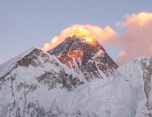
- Some of the world’s highest peaks (Annapurna I: 8,091m, Machhapuchhere: 6,993)
- World’s deepest gorge: Kali Gandaki and one of the world's highest altitude lakes Tilicho
- Most popular trekking destination (76407 in 2000)
- Two distinct climatic regions (3000mm annual rainfall in the south (cis Himalayas) and <500mm annual rainfall in the north (trans-Himalayas) within a span of 120 km and altitude of 1000-8000m
22 different forest types
- A total of 1226 species of plants (1140 species in the cis Himalayas) including 38 Orchid species and 9 Rhododendron species
- 101 species of mammals including snow leopard, Musk deer, Tibetan Argali, Tibetan wolf, and Tibetan fox. 474 species of birds including 38 breeding species of birds at risk in Nepal, all six Himalayan pheasants found in Nepal. 39 species of reptiles and 22 species of amphibians.
- Nepal’s largest protected area and first conservation area with the entire habitat gradient from sub-tropical sal forest to perennial snow.
- More than 100,000 inhabitants and more than 10 ethnic groups (Tibeto Burbese: Gurung, Thakali, Bhotia, Ethnic Tibetan and Magar and Indo Aryan: Brahmin, Kshetri, Kami, Damai, and Sarki)
How to get there?
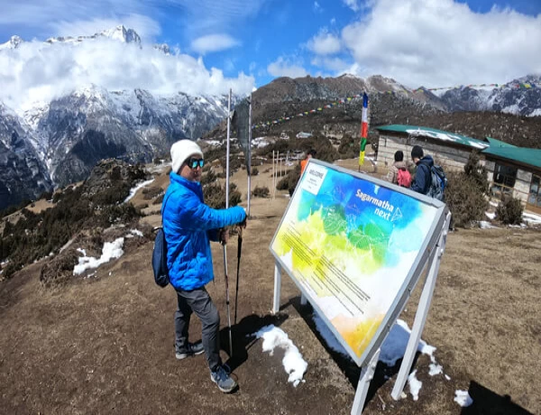
Annapurna Conservation Area (ACA) is located near Pokhara, a town easily accessible from Kathmandu by air and road. Bus or taxi services are available from Pokhara to Jomsom which is located in the northern part of Annapurna Conservation Area. An alternative route is to reach Phedi by bus or taxi and walk for 1.5 days to reach Ghandruk via Dhampus -Landruk. Annapurna Sanctuary and base camp are located a 6-7 days trek from Ghandruk.
Here is a List 10 Best Trek in Annapurna Conservation Area Project (ACAP)
- Short Annapurna Circuit Trek -7 Days
- Short Annapurna Base Camp Trek -06 Days
- Annapurna Base Camp Trek via Poon Hill -13 Days
- Annapurna Short Trek -03 Days
- Khopra Ridge Community Base Trek -05 Days
- Tilicho Lake Trek -09 Days
- Nar Phu Valley Trek -9 Days
- Upper Mustang Trek -15 Days
- Mardi Himal Trek -10 Days
- Poon Hill Trek -02 Days
If you need any further information, please don t hesitate to contact us at Nepal Mother House anytime.
Kanchenjunga Conservation Area
Kanchenjunga Conservation Area Project (KCAP) is named after Mt. Kanchenjunga (8,586m) - the second-highest mountain in Nepal and the third-highest in the world. Kanchenjunga was designated as a conservation area in March 1998. It covers an area of 2035 sq. km. in Taplejung district, which lies in the northeast corner of Nepal.
Taplejung district is also renowned for high peaks (eleven peaks higher than 7,000 m) and glaciers. The conservation area with unique mountain ecosystems is envisioned as a tri-national peace park with the Tibet Autonomous Region (TAR) of China to the north and Sikkim, India, in the east. Sikkim already has Khangchenzonga National Park adjoining KCA whereas the extension of Qomolungma Nature Reserve in TAR, to cover the land bordering KCA, is in progress.
In April 1997, the Government of Nepal declared the Kanchenjunga region as a Gift to the Earth as part of WWF’s Living Planet Campaign 2000.
How can one reach the Kanchenjunga region?
Kathmandu - Suketar by air Illam - Phidim - Taplejung Bazar by bus.
Heritage Significance of Kanchenjunga Conservation Area
The Kangchenjunga Conservation Area (KCA) in the eastern Himalayas comprises some of the most stunning scenery in all of Nepal. Not only does this region host the third-highest peak in the world (Mt. Kangchenjunga), but it is also a global hotspot for plant biodiversity. Botanist has identified twenty-three species of rhododendrons growing in the area. In this eastern Himalayan setting, glacial streams cut through high ridges creating remote and steep valleys where traditional farming practices are a way of life. Tucked within these hidden valleys, one can encounter rich forests that support more than 250 species of birds and endangered wildlife. A few days of walking will lead you to high-elevation pastures where yaks graze languidly and colorful alpine flowers bloom. Throughout the KCA, you will encounter a medley of ethnicities that continue to practice traditional subsistence lifestyles, their cultural and religious practices adding to the area's rich cultural heritage.
Vegetation of Kanchenjunga Conservation Area
Subtropical Evergreen Forest: 800-1,200m Schima wallichii, Engelhardtia spicata, and Castanopsis indica characterize the evergreen tree species. However, much of the original forests have been converted to agricultural land. Lower Temperate Forest: 1,200-2,500m. Also, it is known as the Lower Temperate Mixed Broadleaf Forest. Home to broadleaf deciduous trees represented by Quercus, Castanopsis, Rhododendron arboretum, and some members of the laurel family. Trees shed their leaves in the spring as a result of drought stress. Upper Temperate Forest: 2,500-3,500m. Also called Upper Temperate Mixed Forest or Temeperate Cloud Forest. Floristic influences from both lower and higher zones. Here, deciduous oaks, maples, laurels, and branches intersperse with evergreen firs, magnolias, junipers, and rhododendrons. Most trees are deciduous. Trees are covered in mosses and epiphytic plants due to the high moister content in this zone. Daphe Bholua ( locally known as Lokta ) is harvested from these forests. Sub-alpine Zone: 3, 500-3,900m. Mostly evergreen conifers interspersed with a few cold-hardy deciduous species. South-facing slopes are usually tree-less or contain pure stands of stunned rhododendrons. North-facing slopes have juniper, fir, willow, birch, and rhododendrons. In Ghunsa Valley, look out for extensive stands of the spectacular Himalayan larches (Larix griffithiana) that turn the hillsides a golden-yellow in the fall.
The Most Popular Trekking List of the Kanchenjunga Region
- Kanchenjunga Circuit Trek -17 Days
- Kanchenjunga Base Camp Trek -22 Days
- Kanchenjunga South Base Camp Trek -9 Days
Alpine Zone: 3,900-4,600m. Woody vegetation in this zone of moist alpine scrub consists of stunned junipers, roses, rhododendron, gentian, and saxifrage abound. Hardy alpine grasses include Carex, Juncus, and Poa. Look out for herds of blue sheep foraging on hillsides above the treeline. Perhaps, you may see signs of snow leopards that prey on these she.
Manaslu Conservation Area
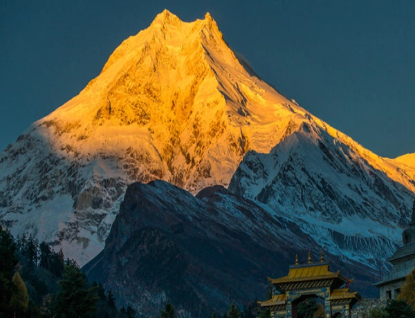
Manaslu was declared a “Conservation Area” in December 1998 by HMG’s Ministry of Forest and Soil Conservation under the National Parks and Wildlife Conservation Act of Nepal. It covers an area of 1663 sq. km. The region harbors a mosaic of habitats for 33 species of mammals, 110 species of birds, 11 species of butterflies, and 3 species of reptiles. There are approx 2000 species of plants, 11 types of forests, and over 50 species of useful plants. The bio-climatic zones vary from sub-tropical to Nival. The altitude rises from a mere 600m. to the summit of Mt. Manaslu (8,163), the eighth highest peak in the world.
Climate of Manaslu Conservation Area Project (MACP)
The Manaslu Conservation Area Project (MACP) from Arughat to Larkhe La (Pass 5,160m), has six climatic zones: tropical, subtropical, temperate, subalpine, alpine, and arctic. The extreme climatic contrasts within the 100 km trail between Arughatand Samdo are associated with tremendous differences in elevation, topography, and precipitation. The tropical climate zone lies in the low-level river basins of the Buri Gandaki, Marsyangdi, and other rivers, lowland valleys, and lower hills below the elevation of 1000 m. A subtropic climatic zone exists between 1000m and 2000m where the average summer and winter temperature range between 31 to 34oC and 8 to 13oC respectively.
The temperature climatic zone lies at higher hills above 2000 m and below 3000m.In this zone, summer temperatures range from 22 to 25oC, and winter temperatures range from -2 to 6oC. Frosts and snowfall are common during winter(January and February ). The subalpine climatic zone lies between 3000 m and 4000 m where snowfall occurs for about four to six months ( December to May ).In this zone, winter is very cold, and even in summer, the temperature is not high with a mean annual temperature of 6 to 10oC. The alpine zone between 4000 and 5000 m is mostly open meadows. The Arctic climatic zone lies at elevations above 4500m.
The snow line is at about 5000 m. Precipitation is in the form of snow and the temperatures drop far below freezing. The monsoon occurs between June and September providing about three-fourths of the total rainfall. The post-monsoon period (October to November) and the winter months (December to February) are usually dry. The average rainfall is around 1900 mm per annum. In general, the southern part of the region remains cloudier and wetter than the upper subalpine areas and alpine areas.
How to get there?
The trek starts from Gorkha, home of the legendary Gorkha soldiers, and follows the meandering Budhi Gandaki River or the Darundi River before reaching Larke Pass(5,160 m.) and crossing over into the Manang district of ACAP.
Here is a List of the Most Visited Manaslu Region Trek:
- Manaslu Circuit Trek -14 Days
- Short Manaslu Circuit Trek -10 Days
- Manaslu Circuit with Tsum Valley Trek -18 Days
- Tsum Valley Trek -14 Days
- Manaslu Circuit Side Trip -19 Days
Vegetation of Manaslu Conservation Area Project (MACP)
The vegetation of the area can be divided into three main categories, based mainly on the altitude, viz. Low hill, Middle mountain, and High mountain types. Each category has its own types of dominant forests and other associated species. The types of vegetation, however, tend to overlap the adjoining ones at places, especially in relation to aspect and micro-climate. While the forest types are quite distinct, the underlying as well as adjoining flora in different forest types do not vary so sharply.
Gaurishankar Conservation Area (GCA)
The Gaurishankar Conservation Area is an important area in the high Himalayas that has a long history of cultural value, a broad range of plants and animals, very high and low altitudes, and strong community-first conservation strategies. It is particularly significant for connecting important national parks, safeguarding flagship species, and encouraging sustainable ways of making a living.
ust let me know if you want to know about hiking trails, how to observe wildlife, or how to aid GCAP programs.
An Overview and a Look Back
The Sacred Himalayan Landscape is a 2,179 km² area in northeastern-central Nepal that encompasses the districts of Dolakha, Sindhupalchok, and Ramechhap. It is located next to the Tibetan Plateau and connects the famous Langtang and Sagarmatha National Parks. The area is named after Mt. Gaurishankar, which is about 7,134 m high and is named after the Hindu gods Gauri and Shankar. The National Trust for Nature Conservation (NTNC) manages it under a 20-year agreement with the government.
Climate and geography zones
The altitude range is from 968 m to 7,181 m, and it includes a wide range of eco-zones, from subtropical to nival (glacial).
There are 16 different types of woods, including Pinus roxburghii, Schima-Castanopsis, Alnus, other types of pines, rhododendron, oaks, juniper, and alpine scrub.
About 44.5% of the area is covered by forests and bushes, 8.8% is cultivated land, 2.8% is glaciers, and the rest is grasslands and bare ground.
Biodiversity Highlights
The red panda, snow leopard, Himalayan black bear, Himalayan thar, musk deer, pangolin, Asian golden cat, wolf, and common leopard are all animals.
- Birds: People have seen about 235 different kinds.
- There are 14 snakes, 10 amphibians, 8 lizards, and 16 varieties of fish in it.
Camera-trap investigations show that snow leopards and common leopards live together at about 4,300 m in Lapchi Valley. This means that this is an important habitat for predators at high altitudes.
A research in Marbu and Kalinchok shows that red pandas are grouped together, with evidence of 5–1.7 occurrences per km.
Work for the community and the environment
There are 22 Village Development Committees, and the main office is in Charikot, which is around 131 km from Kathmandu.
There are people of many various ethnicities who dwell there, including as Tamang, Sherpa, Chhetri, Newar, Thami, Dalit, Magar, Gurung, Brahman, Sunuwar, and Surel.
Farming, raising animals, mining, eco-tourism, and manufacturing traditional crafts are all essential ways to make a living.
The Gaurishankar Conservation Area Project (GCAP) of NTNC includes monitoring wildlife with camera traps and surveys
- Reducing conflict between people and animals (via insurance plans and training)
- Building up the community's ability to handle forest fires and manage forests
- Supporting eco-trails and homestays (10 new ones)
- Focused efforts on endangered species, including Chinese pangolins, by raising awareness and community-led patrols
Access and Visitor Experience
There are large trails that pass through Rolwaling, Lapchi, Kalinchok, and the Tsho Rolpa glacier lake.
You can take a bus from Kathmandu to Singati or Chhetchhet. There are a multitude of hiking trails, and some of them go to the Jiri–Everest trails.
Visitors from Nepal have to pay NPR 100 to get in, visitors from SAARC countries have to pay NPR 1,000, and tourists from other countries have to pay NPR 3,000.
Recent Problems
A wildfire that burned 600 hectares in January 2025 harmed forest areas that are important to the red panda. A united task force put out the fire after nine days.
Importance for Conservation
- It works as a biological corridor that connects high-altitude ecosystems across the Himalayas.
- The presence of predators at high elevations shows that the ecosystem is robust and working well.
- Community-led projects and other ways to make a living help both biodiversity and long-term growth.