Gosaikunda Trek Trail After the Rasuwa Flood: Alternative Routes, Safety Advice, and Latest Access Update
Updated: 27 August 2026
The devastating flash flood that struck the Rasuwa–Tibet border area on 26 August 2026 has significantly disrupted travel through northern Rasuwa and the traditional access corridor toward Langtang and Gosaikunda.
For trekkers, pilgrims, and travel companies planning a Gosaikunda Trek, the most important message right now is simple:
Do not use the regular Dhunche route until authorities confirm that it is safe and open.
The Ministry of Culture, Tourism, and Civil Aviation has advised travelers returning from Gosaikunda not to descend through the usual Dhunche route and has directed them toward an alternative route through Dupcheshwor.
This does not mean that Gosaikunda is permanently inaccessible.
It means that the normal approach has been disrupted, and trekking plans must be adapted to the current conditions on the ground.
Important: Mountain routes can change rapidly after floods, landslides, and extreme weather. The alternative routes described below should be treated as route options requiring current local verification—not as a guarantee that every section is open or safe.
What Happened in Rasuwa on 26 August 2026?
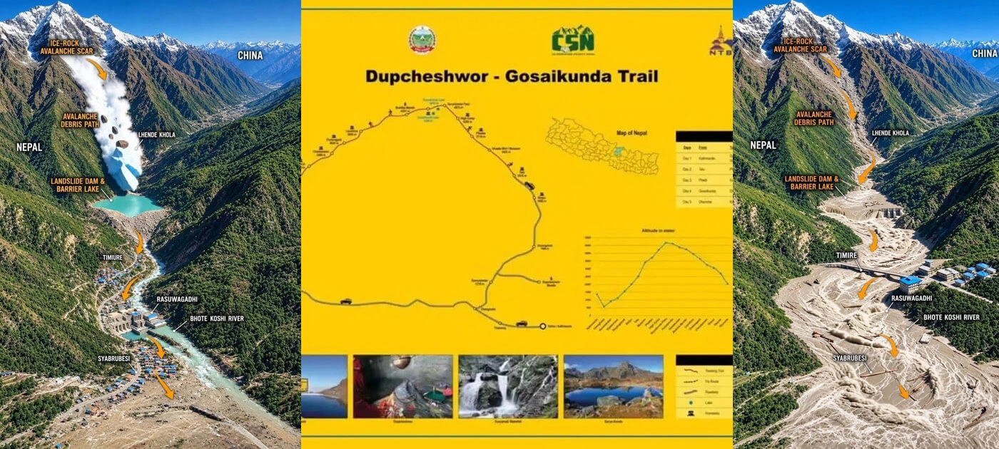
On the morning of 26 August 2026, at 9:05 AM, a massive surge of water and debris moved through the Bhotekoshi River corridor in northern Rasuwa, at Lhende Khola, after an ice-and-rock-related event near the Nepal–Tibet border.
The flooding severely affected Rasuwagadhi, Timure, Syabrubesi, Mailung, and Betrawati-trishuli before moving downstream toward the Trishuli corridor.
The Department of Roads reported that approximately 41 kilometers of the Betrawati–Rasuwagadhi road were damaged, with several bridges washed away. Officials were still assessing the full extent of destruction, including damage along the Syabrubesi border section.
Settlements, markets, hydropower facilities, roads, 22 bridges, 5 Beli bridges, and communications infrastructure also sustained damage. Search-and-rescue and damage-assessment operations have been continuing. Thousands of people have been missing after devastating floods. Where 900 Dad Bodies were founded and 4,500 people are missing.
The event has therefore created a much larger problem than a temporary road closure. The entire travel environment around parts of the Bhotekoshi–Trishuli corridor has changed. The travel environment along parts of the Bhotekoshi–Trishuli corridor has changed significantly.
Glacier Collapse Near Mt. Langtang Lirung Triggers Massive Ice Avalanche and Flash Floods Along Nepal–Tibet Border
The reason for the glacier's collapse is unknown. Initially Nepali officials had suggested an earthquake in the region could have been the cause, but later the U.S. Geological Survey said the tremor reported was actually seismic energy from the collapse of glacial rock and ice, followed by debris flow.
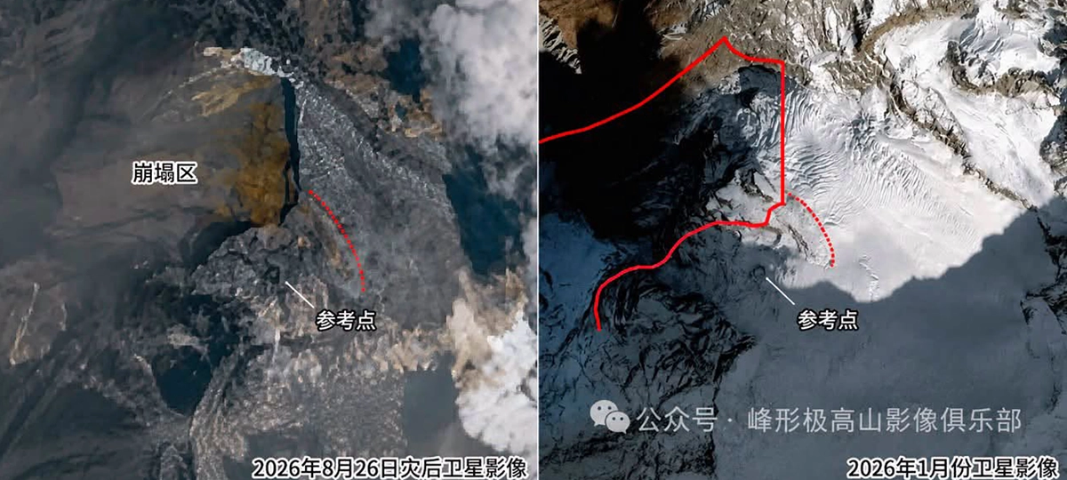
Comparing imagery taken a few days earlier, satellite imagery shows a large part of a glacier near Mt. Langtang Lirung 7,234 m (23,734 ft) broke off. A flood of ice and stone roared down the Lhende Khola river that runs along the mountainous Nepal/Tibet border.
The mudslide struck the Gyirong port in Tibet and Nepal, triggering high-speed flash floods that washed away whole roads, power projects, and flooded villages.
Verified videos showed dozens being carried away at the border.
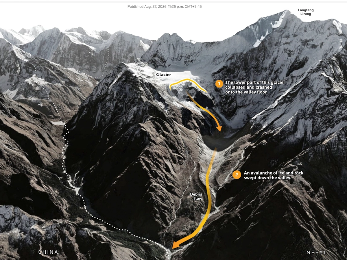
The ice-avalanche debris flow that triggered the mudslide moved at about 50 meters (165 feet) per second, leaving little time for people to react, Chinese government geologist Guo Zhaocheng said, and extended for more than 20 km (12 miles).
High-mountain rock and ice can be destabilized by conditions created by climate change, said Simon Cox, chief scientist at Earth Sciences New Zealand's Mountains to Sea program.
Is Gosaikunda Trek Open After the Rasuwa Flood?
The short answer: the normal Dhunche approach should be avoided for now. Travellers should not assume that Kathmandu–Dhunche–Gosaikunda is operating normally.
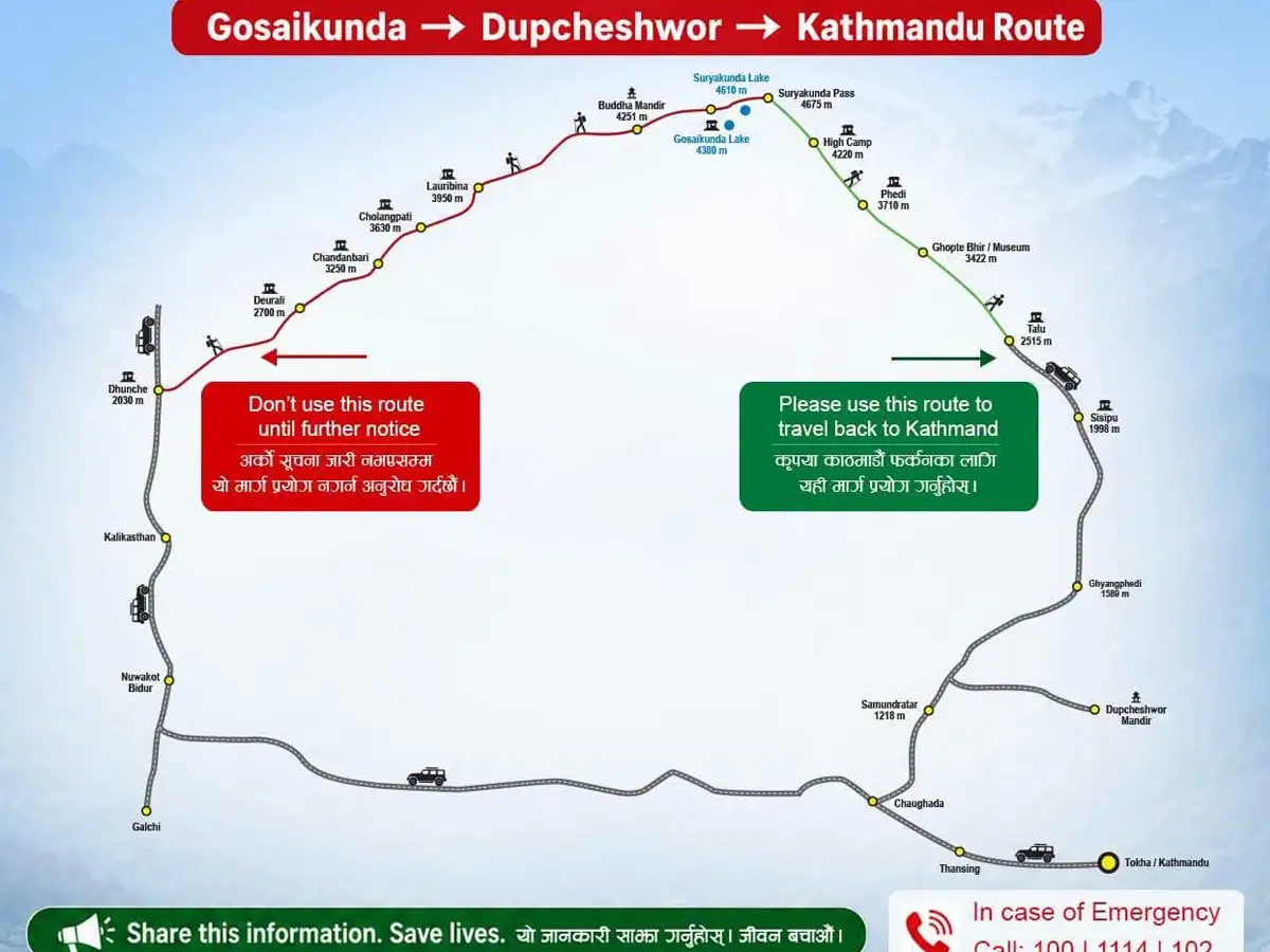
The Tourism Ministry has specifically asked tourists and pilgrims returning from Gosaikunda not to use the regular route toward Dhunche until further notice. The ministry has instead identified Gosaikunda–Dupcheshwor–Kathmandu as an alternative return route.
This is particularly important for trekkers who are already in the Gosaikunda and Langtang Valley area. If you are currently trekking around Langtang Valley, Gosaikunda, Lauribina, Sing Gompa, or nearby areas, speak with your guide, lodge operators, and local authorities before beginning your descent.
Do not make a route decision based only on social media posts or an old trekking map.
Alternative Route to Gosaikunda: Dupcheshwor Approach
For travellers who need to avoid the damaged Rasuwa corridor, an alternative approach from the Nuwakot side is being considered and promoted. The route can be described broadly as
Kathmandu → Dupcheshwor → Sisipu → Talu/Gyangphedi → Phedi → Suryakunda → Gosaikunda
The precise trail used may vary according to current local conditions, trail availability, and the advice of local guides. This route is important because it approaches the Gosaikunda region from a different direction rather than relying on the flood-affected Dhunche–Rasuwa corridor.
However, trekkers should understand one crucial point: An alternative route is not necessarily an easier route.
Some sections are remote, steep, and high in altitude. Facilities can be more limited than on the traditional Gosaikunda approach, and trail conditions need to be checked locally before departure.
Kathmandu to Dupcheshwor
The journey begins from Kathmandu toward Dupcheshwor in Nuwakot, about 75 kilometers, taking a 3- to 4-hour drive.
Dupcheshwor is well known for the sacred Dupcheshwor Mahadev Temple and provides an important connection between the Kathmandu Valley and the mountain trails leading toward the Gosaikunda region.
For trekkers, the advantage of starting from this side is that the approach does not depend on travelling north through the severely affected Rasuwa road corridor.
Nevertheless, check the road and trail conditions immediately before departure.
Dupcheshwor to Sisipu and the Higher Trail
From Dupcheshwor, the route continues through rural settlements toward Sisipu and the higher mountain trail system.
As the trail moves away from the road network, trekkers should expect more remote conditions.
This means:
- fewer transport options;
- fewer accommodation choices;
- limited communication in some areas;
- more dependence on local guides;
- greater exposure to changing mountain weather.
Following a disaster, even an established trail can be affected by landslides, damaged footbridges, erosion, or fallen debris.
For this reason, local trail verification is essential.
Sisipu–Talu–Phedi
The trail gradually climbs through the hills toward Talu/Gyangphedi and Phedi. Compared with the traditional Dhunche approach, this route can feel considerably more remote. Trekkers should make sure that accommodation, food supplies, and water sources are available before committing to each section. Do not assume that guesthouses shown on an old itinerary are currently operating. After a major natural disaster, local communities may themselves be dealing with damaged infrastructure and limited supplies.
Phedi to Suryakunda
The section toward Suryakunda is one of the more demanding parts of the alternative approach. The route reaches high Himalayan terrain, with the Suryakunda area generally described at around 4,600–4,675 meters, depending on the exact route and reference point. This means altitude becomes a serious consideration. A trekker who has already spent several days at lower elevations may still need to manage the effects of rapid elevation gain. The alternative route should therefore not be marketed as a simple detour around a damaged road. It is a genuine high-altitude trekking route.
Suryakunda to Gosaikunda
From the Suryakunda area, the trail continues toward the sacred Gosaikunda lake system. Gosaikunda sits at approximately 4,380 meters and is one of Nepal's most important high-altitude pilgrimage and trekking destinations. The surrounding landscape is characterized by alpine terrain, rocky ridges, mountain lakes, and dramatic Himalayan scenery. For trekkers who are physically prepared and travelling with reliable local support, the alternative approach can provide a different way of experiencing the Gosaikunda and Langtang valley region.
But once again:
Current trail conditions must come before the itinerary.
Alternative Exit From Gosaikunda: Ghopte–Tharepati–Helambu
Trekkers already in the Langtang Valley, Kyanjin Gumba, and the Gosaikunda region may also consider the established route toward Ghopte and Tharepati, continuing through the Helambu region toward Kathmandu.
A possible trekking connection is
Langtang Valley → Gosaikunda → Lauribina La → Phedi → Ghopte → Tharepati → Kutumsang → Chisapani →Sundarijal → Kathmandu or Melamchi Gaun → Kathmandu
This route avoids descending directly through the flood-affected Dhunche corridor.
From the Langtang Kyanjin Gumba to Lama Hotel, Thulo Syabrubesi, Chandanbari, and Gosaikunda side, the trail crosses the high Lauribina La area, then descends toward Phedi and Ghopte before continuing toward Tharepati and the Helambu trail network of the Langtang Gosaikunda helambu trek.
The route is established, but that does not mean every section is automatically safe after the recent disaster.
Rainfall, landslides, trail erosion, and damaged infrastructure can affect mountain routes far beyond the immediate flood zone.
Gosaikunda Trek Alternative Routes: Which One Should You Take?
There is no single answer for every trekker.
The appropriate route depends on:
- your current location;
- the latest trail condition;
- weather;
- road accessibility;
- accommodation availability;
- physical fitness;
- altitude experience;
- guide availability;
- communication;
- emergency and evacuation options.
For someone already at Langtang Valley and Gosaikunda, the safest decision may be different from the best route for someone still in Kathmandu.
That is why real-time local information is more valuable than a fixed online itinerary right now.
Are Alternative Gosaikunda Routes Safe?
This is an important question, and the honest answer is:
No trekking route should currently be described as completely risk-free.
The alternative routes avoid some of the worst-affected road corridors, but they remain Himalayan mountain trails.
Potential hazards include:
Landslides
Recent flooding can destabilize slopes and increase the risk of rockfall and landslides.
Damaged bridges
Avoid crossing any bridge that is visibly damaged or whose safety is unconfirmed.
Sudden river-level changes
Water levels can rise rapidly following rainfall or upstream events.
High altitude
Sections of the alternative routes rise above 4,500 meters.
Weather
Clouds, rain, wind, and poor visibility can develop quickly in the high mountains.
Limited rescue access
Remote trails generally have fewer immediate evacuation options than road-accessible areas.
Communication problems
Flooding and infrastructure damage may affect mobile networks, electricity, and other communication systems.
What Should Trekkers Do Before Starting?
If you are planning a Langtang and Gosaikunda Trek in the coming days, do not simply follow your original pre-flood itinerary.
Instead, reassess the journey from the beginning.
1. Confirm the road
Check whether the road to your proposed trailhead is actually open.
2. Confirm the trail
Ask local guides or authorities about the latest trail conditions.
3. Check bridges
Confirm that river crossings and footbridges are safe.
4. Confirm accommodation
Contact lodges ahead of time where possible.
5. Check communication
Make sure your guide has a reliable way to communicate in an emergency.
6. Review evacuation options.
Understand what happens if a trekker becomes sick or injured.
7. Watch the weather.
Do not begin a high-altitude crossing when conditions are deteriorating.
8. Carry sufficient essentials.
Water, food, warm clothing, rain protection, navigation equipment, first-aid supplies, and appropriate trekking equipment become even more important when infrastructure is disrupted.
If You Are Already at Langtang and Gosaikunda
If you are currently at Langtang and Gosaikunda or in the surrounding trekking area, do not rush downhill simply because you have heard that roads are damaged.
First ask:
Where is the safest confirmed route today?
Then consult:
Your trekking guide → Local lodge → Local authorities → Tourism authorities
The Tourism Ministry's current direction is that travelers returning from Gosaikunda should avoid the regular Dhunche route and use the Dupcheshwor alternative toward Kathmandu until further notice.
Because conditions can change quickly, you should reconfirm this advice before every stage of the journey.
What Caused the Rasuwa Flood?
Early reports initially left the exact cause uncertain. Subsequent geological and satellite-based reporting has pointed toward a major ice-and-rock collapse/landslide in the upper Himalayan region on the side of Langtang Lirung Mountain, which generated a destructive surge of water, mud, and debris.
The US Geological Survey and subsequent reporting have helped establish that the event was associated with a major landslide/ice-rock collapse rather than being simply an ordinary rainstorm flood.
Because scientific assessments are still developing, tourism websites should avoid presenting every early satellite interpretation or social media claim as established fact.
A responsible description is:
A major ice-and-rock collapse in the Himalayan headwaters triggered a catastrophic surge of water, mud, and debris through the Bhotekoshi–Trishuli river system.
As further scientific investigations are released, this explanation can be updated.
What Does the Disaster Mean for Langtang Trekking?
The impact on trekking depends heavily on the exact route. The Langtang Valley Trek normally uses the Syabrubesi access corridor, which has been severely affected by the disaster.
That means travelers planning a Langtang trip should not assume that the usual Kathmandu–Syabrubesi road journey is currently operating normally.
Gosaikunda is different because there are alternative approaches from other directions. Nevertheless, trekkers should wait for current official and local information before travelling to affected areas.
Responsible Advice for Trekking Agencies
For trekking companies, this situation requires more than simply replacing one itinerary with another.
A responsible operator should confirm:
- Is the route officially open?
- Has the trail been inspected locally?
- Are bridges usable?
- Are lodges operating?
- Is food available?
- Is communication functioning?
- Can emergency assistance reach the area?
- Are local authorities permitting trekking?
- Has the weather stabilized?
- Is the proposed route appropriate for the client's physical ability?
Only after these questions have been answered should a trekking itinerary be confirmed.
For clients who already have reservations, proactive communication is essential.
- Please explain the situation honestly.
- Do not create unnecessary fear.
- But do not minimize the risks either
What Trekkers Should Not Do
After a major natural disaster, responsible trekking also means knowing what not to do.
Do not:
- travel through the closed or restricted Dhunche corridor;
- cross-damaged bridges;
- walk beside swollen rivers;
- enter active landslide zones;
- approach damaged hydropower structures;
- Use old GPS tracks without checking current conditions
- rely on social media rumors;
- trek alone through unfamiliar remote terrain;
- assume yesterday's trail condition is today's condition;
- Prioritize completing the itinerary over personal safety.
Nepalese authorities have also urged people to avoid unnecessary travel near rivers and landslide-prone areas and to follow official information rather than rumors.
Gosaikunda Is Not the Problem Access Is
It is important not to create the impression that Gosaikunda itself has disappeared or that the entire region is permanently closed.
Gosaikunda remains where it has always been.
The immediate issue is access.
The traditional road and trekking corridor through Dhunche and northern Rasuwa has suffered severe disruption, while rescue, recovery, and infrastructure assessment continue.
For travellers, this means the question is no longer simply
“Can I trek to Gosaikunda?”
The better question is
“Which route to and from Gosaikunda is currently confirmed as safe and appropriate?”
That is the question trekkers, guides, and agencies should be asking every day until the situation stabilizes.
Gosaikunda Route Status After the Rasuwa Flood
|
Route
|
Current advice
|
Verify with Local Expert |
|
Kathmandu → Dhunche → Gosaikunda
|
Avoid until authorities confirm safe access.
|
Yes |
|
Gosaikunda → Dhunche → Kathmandu
|
Do not use until the regular route is reopened/cleared.
|
Yes |
|
Gosaikunda → Dupcheshwor → Kathmandu
|
Current alternative directed by the Tourism Ministry; verify conditions before travelling
|
Yes—New Route |
|
Dupcheshwor → Sisipu → Talu/Phedi → Suryakunda → Gosaikunda
|
Potential alternative approach; local trail verification essential
|
Yes—New Route |
| Gosaikunda → Ghopte → Tharepati → Helambu → Kathmandu |
Established alternative trekking corridor; confirm current trail conditions |
Yes—Classic Route |
Frequently Asked Questions About Gosaikunda Trek After the Flood
Is Gosaikunda Trek open after the Rasuwa flood?
The normal Dhunche approach should currently not be treated as open for routine trekking. The Tourism Ministry has advised travellers returning from Gosaikunda to avoid the regular Dhunche route and instead use the Dupcheshwor alternative until further notice.
Can I still visit Gosaikunda?
Potentially, but the answer depends on current route and trail conditions. Trekkers should not rely on pre-flood itineraries and should confirm the latest situation with local authorities and experienced guides before travelling.
What is the alternative route to Gosaikunda after the Rasuwa flood?
An alternative approach can be made from the Nuwakot side through Dupcheshwor, Sisipu, Talu/Gyangphedi, Phedi, and Suryakunda toward Gosaikunda, subject to current trail conditions.
What route should I use to leave Gosaikunda?
The Tourism Ministry has directed travelers returning from Gosaikunda to use the Dupcheshwor route toward Kathmandu rather than the regular Dhunche route until further notice.
Is the Dupcheshwor route easy?
No. It should not be considered merely a convenient road detour. Parts of the route involve remote and high-altitude mountain terrain and require proper trekking preparation.
Can I trek alone?
This practice is not advisable in the immediate aftermath of a major natural disaster. An experienced local guide can provide current information about trails, bridges, weather, accommodation, and emergency options.
Is Langtang Valley Trek also affected?
The traditional Langtang access route through Syabrubesi has been affected because the road corridor and surrounding infrastructure suffered major flood damage. Travellers should wait for confirmed access information before beginning a Langtang trek. However, it is possible to visit Langtang from Tharepati, Ghopte, Gosaikunda Pass, or Dupcheswar.
Final Advice: Safety Comes Before the Itinerary
The 26 August 2026 Rasuwa disaster is an ongoing emergency, not simply a temporary road obstruction. The flood severely affected communities and infrastructure along the Bhotekoshi and Trishuli corridors, while rescue and damage-assessment operations continue.
For trekkers, the right approach is
- Check. Confirm. Reassess. Then travel.
- Do not let a fixed itinerary force you into an unsafe route.
- Do not depend on old maps, outdated GPS tracks, or social media rumors.
- Do not assume that an alternative trail is automatically safe simply because it avoids the damaged highway.
- And do not hesitate to postpone your trek if local conditions are uncertain.
- The Himalayas will still be there.
- A delayed trek is far better than taking an unnecessary risk on an unstable mountain trail.
For the latest situation, travellers should monitor information from the Nepal Tourism Board, the Ministry of Culture, Tourism and Civil Aviation, the Department of Hydrology and Meteorology, district administration authorities, the National Disaster Risk Reduction & Management Authority, security agencies, and trusted local trekking professionals.
Above all, remember that the safety of trekkers, guides, porters, and local communities must come before completing an itinerary.
Stay informed. Stay flexible. Stay safe.
This article should be updated whenever official authorities release new information about road access, trail conditions, safety restrictions, or reopening of the Rasuwa–Dhunche corridor.